
Open an online map, type in your address, and you’ll see neat lines outlining your property. At first glance, it feels accurate. Because of that, many homeowners assume those lines tell the full story. However, a licensed land surveyor knows those maps only show a rough picture, not the legal truth. That difference matters the moment money, neighbors, or construction enter the conversation.
Online maps work well for directions and planning routes. Yet when it comes to property ownership, they fall short. Let’s look at what a licensed land surveyor verifies that online maps simply cannot—and why that matters for real people.
Why Online Maps Feel Trustworthy
Online maps look clean and professional. They load fast, zoom smoothly, and label parcels clearly. Because of that, they feel official. Many real estate listings even use them, which adds another layer of confidence.
Still, these maps serve as visual tools, not legal records. They pull data from many sources, stitch it together, and display it for general use. As a result, they aim for convenience, not precision. That gap creates problems when people rely on them for decisions that carry legal weight.
The Big Difference: Pictures vs. Proof
A licensed land surveyor does not guess or estimate. Instead, they verify facts that hold up under scrutiny. Online maps show what might be there. A surveyor confirms what is there, based on law, records, and evidence on the ground.
This difference explains why surveyors still matter in a world full of digital tools. When a boundary comes into question, opinions fade and proof takes over.
Property Corners: The Foundation of Ownership
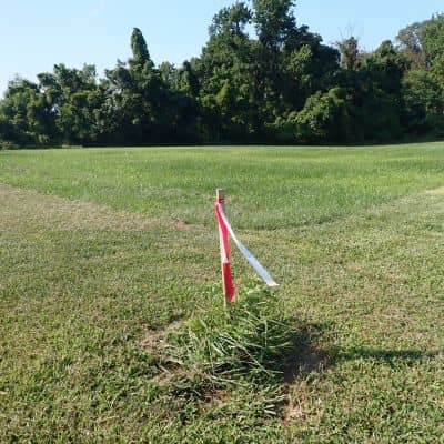
Property corners define ownership. Without them, boundary lines have no anchor. Online maps rarely show true corner locations. Even when they appear to, those points often sit several feet off.
A licensed land surveyor searches for existing corner markers, such as iron pins or monuments. When those markers go missing or get disturbed, the surveyor works through records and field evidence to re-establish them. This process requires judgment, not software.
Because of that, surveyors do not rely on a single source. They weigh history, location, and physical clues before making a call. Online maps cannot do that.
Conflicting Records That Maps Ignore
Many property owners assume deeds and plats always agree. In reality, they often don’t. Older descriptions may use landmarks that no longer exist. Past surveys may conflict with newer ones. Subdivision layouts may shift over time.
Online maps do not resolve these conflicts. They simply display one interpretation.
A licensed land surveyor, on the other hand, compares all available records. They look for overlaps, gaps, and inconsistencies. Then they apply professional standards to resolve them. This step matters because the wrong interpretation can shift a boundary enough to cause serious disputes.
What’s on the Ground Matters
Fences, driveways, sheds, and walls tell a story. However, that story does not always match legal ownership. Many improvements get built in the wrong spot without anyone noticing for years.
Online maps don’t evaluate physical evidence. They also don’t explain whether a fence reflects a true boundary or a long-standing mistake.
A licensed land surveyor checks how physical features line up with legal descriptions. If something crosses a line, the surveyor documents it clearly. That clarity helps owners decide what to fix, negotiate, or leave alone.
Encroachments and Easements
Encroachments create stress fast. A driveway that crosses a line or a shed that sits too close can delay a sale or spark an argument. Easements add another layer of complexity because they limit how land can be used.
Online maps rarely show these issues clearly. Even when they do, the information may not be current or complete.
Surveyors verify where encroachments exist and where easements apply. They also show how those rights affect the property. That knowledge protects owners from surprises later.
Why Maps Can Look Right and Still Be Wrong
Satellite images distort edges. Parcel data shifts slightly when systems update. Different layers don’t always align. Because of that, lines that look perfect on screen may sit feet away from reality.
These small differences don’t matter for navigation. However, they matter a lot for ownership.
A licensed land surveyor expects these issues. They don’t treat digital data as final. Instead, they use it as one piece of a larger puzzle.
When Trusting Online Maps Backfires
Problems usually appear during key moments, such as:
- Replacing or moving a fence
- Buying or selling property
- Building close to a boundary
- Dealing with a neighbor concern
In each case, online maps give false confidence. People move forward, only to discover later that the line isn’t where they thought. At that point, fixing the mistake costs more than checking it upfront.
Accountability Makes the Difference
Online maps come with disclaimers. They warn users not to rely on them for legal decisions. No one signs off on their accuracy.
A licensed land surveyor does the opposite. They sign and seal their work. They stand behind their conclusions. If questions arise later, the survey holds weight because a licensed professional took responsibility for it.
That accountability separates information from evidence.
Technology Helps, But Judgment Leads
Surveyors use modern tools, including GPS and digital mapping. Still, technology supports their work—it doesn’t replace thinking. Experience guides decisions when records conflict or evidence feels unclear.
Online maps lack that judgment. They don’t question themselves or adjust based on context. Surveyors do.
Knowing Beats Guessing
Online maps serve a purpose. They help people visualize land and understand surroundings. However, they don’t establish ownership.
A licensed land surveyor verifies facts that protect property rights. They confirm corners, resolve conflicts, document issues, and provide clarity when it matters most.
When decisions involve money, construction, or peace of mind, guessing never works. Knowing does.