A driveway looks simple at first. You pick a path, clear the space, and lay the surface. That’s how most people picture it. Then problems start to show up. Water collects on the driveway after rain. The slope feels too steep. Cars scrape at the bottom. In some cases, water even runs toward the house instead of away from it. These issues don’t just happen. They usually trace back to one missed step: skipping a topographic survey before the design begins. Most people don’t think much about what a topographic survey shows until they start dealing with these kinds of problems.
If you’re planning a driveway, it helps to understand how your land actually behaves. That’s where a topographic survey makes a real difference.
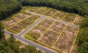
Understanding the Shape of Your Land
At first glance, your property may look flat. Most lots do. But small elevation changes exist across almost every piece of land.
Those small changes matter more than people think.
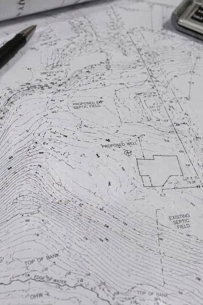
A topographic survey maps how the ground rises and falls. It shows the high points, the low spots, and the direction the land naturally slopes. Once you see how a topographic survey shows your land’s shape, the layout of the property becomes easier to understand.
Instead of guessing, you’re working with a clearer picture of how the land actually behaves. That kind of clarity makes decisions much easier from the start.
Slope Can Make or Break a Driveway
Slope plays a huge role in how a driveway feels and performs. Even a slight mistake can create long-term issues.
If the driveway is too steep, it becomes hard to use. Cars may struggle to climb, especially during wet weather. Over time, the surface can wear down faster.
If the slope is too flat, water has nowhere to go. It collects on the surface, which leads to cracks and damage.
A topographic survey helps find the right balance. It shows the exact grade of the land so the driveway can be shaped to match it.
That way, the driveway works with the land instead of against it.
The Shortest Path Isn’t Always the Best One
Many property owners choose the most direct route from the road to the house. It feels like the easiest option.
But the shortest path can create bigger problems.
That path might cross a low area where water collects. It might require heavy digging to make it usable. In some cases, it creates a slope that feels awkward or unsafe.
A topographic survey shows better options.
It helps you see where the land naturally supports a driveway. You can shift the path slightly and avoid major grading work. That small change can save time and money during construction.
It also leads to a cleaner, more stable design.
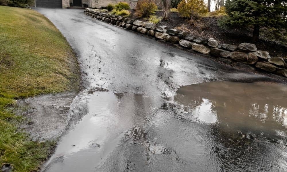
Water Always Follows the Ground
Water does not guess where to go. It follows the slope of the land every time.
If the driveway design ignores that, water becomes a problem.
You may see runoff crossing the driveway or pooling in the wrong areas. In worse cases, water can move toward the home or garage.
A topographic survey shows how water will move across your property. Once you see that, you can plan the driveway to guide water away instead of trapping it.
That step prevents issues that are hard to fix later.
Avoiding Mid-Project Changes
Driveway projects often hit problems once work begins. The ground does not match what people expected.
Contractors may need to adjust the slope, move the path, or bring in extra materials. These changes slow everything down.
They also increase the cost.
A topographic survey reduces those surprises. It gives accurate elevation data before construction starts. Plans stay closer to reality, and the project moves forward with fewer delays.
That kind of preparation keeps the job smooth from start to finish.
Grading Starts With Good Data
Most driveways need some level of grading. The ground may need to be cut down in some areas and built up in others.
Without clear data, it’s hard to know how much work is needed.
A topographic survey gives a clear starting point. It shows where the land needs to change and by how much. That makes grading more precise.
It also helps avoid overdoing the work. You won’t move more soil than necessary, and you won’t fall short either.
That balance keeps the project efficient.
Why This Matters in Bridgeport, WV
Bridgeport has a mix of flat areas and rolling terrain. Some lots look simple but have subtle elevation changes that affect design.
Because of that, driveway planning here needs careful attention.
What looks level may not be level at all. A small slope can turn into a drainage issue if it goes unnoticed.
A topographic survey gives a clear view of the land before any work begins. It helps adjust the design to fit local conditions.
That local insight makes a big difference in how the driveway performs over time.
Start With the Right Information
A driveway is something you use every day. If it’s built wrong, the problems show up quickly.
Fixing those problems later costs more than doing it right the first time.
A topographic survey gives you the information you need before making design decisions. It turns guesswork into a plan that fits your property.
When the land is understood from the start, the driveway works better, lasts longer, and causes fewer issues.
That’s the real value of getting it right early.