Why ALTA Surveys Matter in Real Estate
In today’s high-stakes real estate environment, precision is everything—and that’s where ALTA survey steps in. Whether you’re a buyer, seller, developer, or investor, having an accurate view of a property’s boundaries, easements, and encroachments is critical. These surveys are more than just a formality—they’re a legal and financial safeguard that ensures informed, confident decisions.
What Is an ALTA Survey?
An ALTA survey (American Land Title Association survey) is a detailed land survey prepared according to the standards set by ALTA and the National Society of Professional Surveyors (NSPS). Its purpose is to:
- Define legal boundaries
- Identify improvements and encroachments
- Reveal easements, rights-of-way, and potential risks
These surveys are typically required by:
- Title companies
- Lenders
- Commercial developers
- Institutional investors
ALTA surveys provide the clarity and confidence needed for complex real estate deals, particularly those involving financing and insurance.
A Brief History of Alta Survey
ALTA surveys originated in the early 20th century as part of ALTA’s mission to standardize the real estate title process. Before that, inconsistent surveying methods often led to legal disputes and boundary conflicts.
Over time, Alta surveys have evolved with technological advancements:
- GPS mapping
- Total stations
- GIS integrations
These tools enhance both accuracy and consistency, making Alta surveys the gold standard in commercial real estate.
Key Components of an Alta Survey
An Alta survey includes a combination of physical, legal, and graphical data. Core elements include:
| Component | Purpose |
| Property Boundaries | Verifies legal vs. physical boundaries |
| Improvements | Details buildings, fences, and structures |
| Easements & Rights-of-Way | Identifies usage rights by third parties |
| Encroachments | Notes any structures crossing boundary lines |
| Legal Description | Confirms alignment with title documents |
| Access & Utilities | Shows ingress/egress points and utility lines |
These details allow stakeholders to avoid surprises—and lawsuits—down the line.
Why ALTA Surveys Are Critical in Real Estate
ALTA surveys serve multiple functions in a real estate transaction:
🏡 For Buyers
- Ensure clear ownership boundaries
- Reveal hidden risks like utility easements or encroachments
📜 For Sellers
- Prevent disputes
- Speed up due diligence
🏦 For Lenders & Insurers
- Assess risk accurately
- Verify the legal standing of a property before funding or insuring
In short, no major real estate deal should move forward without one.
How ALTA Surveys Differ from Other Surveys
ALTA surveys are more comprehensive and legally standardized than typical boundary or topographic surveys.
| Survey Type | Use Case | Detail Level |
| Boundary Survey | Confirms property lines | Moderate |
| Topographic Survey | Land elevation and features | Moderate |
| ALTA Survey | Real estate transactions | High |
ALTA surveys follow national standards, making them especially suitable for interstate or institutional transactions.
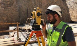
The ALTA Survey Process: Step-by-Step
- Document Review: Deed, title report, prior surveys
- Field Inspection: Using GPS, drones, or total stations
- Feature Mapping: Structures, improvements, encroachments
- Easement Analysis: Identifying legal encumbrances
- Final Report: Map + ALTA/NSPS certification
Surveyors must be licensed and familiar with both national standards and local codes.
Common Issues Found in Alta Surveys
ALTA surveys often uncover risks that would otherwise go unnoticed:
- Boundary Discrepancies: Mismatches between legal and physical boundaries
- Encroachments: Buildings, fences, or driveways crossing property lines
- Easements: Utility or access rights that affect development
- Zoning Conflicts: Land use restrictions not reflected in the title
Early detection can prevent costly delays and lawsuits.
Legal Importance of ALTA Survey
ALTA surveys carry significant legal weight:
- They become part of the property’s legal documentation
- They are used to underwrite title insurance
- They define liability and legal boundaries for all parties
Without one, stakeholders risk unknowingly inheriting legal problems like unpermitted encroachments or unknown easements.
How to Choose the Right ALTA Surveyor
When selecting a surveyor:
✅ Check credentials: Must be licensed and familiar with ALTA/NSPS standards
✅ Evaluate experience: Look for commercial or complex property experience
✅ Assess communication: A good surveyor will keep you informed
Also, ensure they use modern technology (e.g., GPS, GIS) for precise results.
Real Estate Scenarios That Require Alta Surveys
- Commercial property purchases
- Multi-family development projects
- Land refinancing or subdivision
- Title insurance issuance
- Institutional and cross-border investments
Any high-stakes or high-value transaction requires full visibility, and that’s what ALTA surveys deliver.
Conclusion: Precision That Protects Your Investment
In today’s real estate world, having accurate, detailed information about a property isn’t just helpful—it’s essential. That’s exactly what an ALTA survey provides. It gives buyers, sellers, lenders, and insurers the clarity they need to move forward with confidence.
Whether you’re buying, selling, developing, or financing, working with a team that offers reliable ALTA survey services can make all the difference. Instead of guessing or assuming, you’ll have the facts—clearly mapped out. It’s a smarter, safer way to approach any real estate decision.
FAQs
1. What is included in an ALTA survey?
Boundaries, improvements, easements, encroachments, access points, and legal descriptions.
2. Who pays for an ALTA survey?
Typically the buyer or borrower, but it can be negotiated between parties.
3. How long does an ALTA survey take?
Anywhere from 1 to 3 weeks, depending on property complexity.
4. Is an ALTA survey required for title insurance?
Yes, it’s often a condition for issuance on commercial properties.
5. Can I use an old ALTA survey?
Usually not. Most title companies require a current survey, especially if the property has changed.
6. How much does an ALTA survey cost?
It ranges from $2,000 to $10,000+, based on size, location, and complexity.