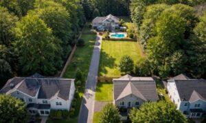
Property lines may look simple on paper. However, in real life, they often cause tension between neighbors. A fence gets built. A shed appears near the edge of a yard. Soon, two people believe the same strip of land belongs to them. Stories like this happen often across the country. Sometimes the argument stays small. Other times it grows into legal trouble. Yet in many cases, the problem starts with one simple issue: no one truly knows where the property line sits. This is where a boundary survey becomes important. It gives clear answers about where one property ends and another begins. More importantly, it helps stop small disagreements before they turn into serious conflicts. That’s why many homeowners choose to confirm their property line with a boundary survey before building fences, sheds, or other structures near the edge of their land.
Why Property Line Disputes Happen So Often
Many homeowners assume they know where their property line is. They may rely on old fences, landscaping, or what a previous owner told them. Unfortunately, those clues can be wrong.
For example, a fence might sit a few feet inside a property line. A hedge may have grown along a line that someone guessed years ago. Over time, these features start to look like the real boundary.
However, when one neighbor decides to build something new, the question suddenly matters.
Imagine this situation. A homeowner plans to install a new fence for privacy. Before building, the neighbor says the fence will cross onto their property. Both sides feel confident they are right.
Without proof, the disagreement quickly becomes emotional. This is usually the moment when a boundary survey becomes necessary to identify the true boundary between properties.
This type of problem happens more often than people think. After all, property boundaries stay invisible unless someone measures them carefully.
Why Fences and Yard Features Can Be Misleading
Many people believe fences mark the exact property line. Yet that idea causes many disputes.
In reality, fences often sit in the wrong place. Sometimes a previous owner placed it there for convenience. Other times the builder guessed where the line might be. Years later, new owners assume the fence is correct.
The same issue happens with:
- garden walls
- driveways
- hedges and trees
- sheds or storage buildings
Over time, these features start to feel permanent. However, they may not match the legal property line at all.
As a result, one neighbor may unknowingly build on land that belongs to someone else. When that mistake surfaces, the conflict can grow quickly.
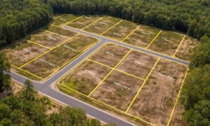
What a Boundary Survey Actually Shows

A boundary survey removes the guesswork. A licensed land surveyor studies property records and then measures the land with precision tools.
First, the surveyor reviews deeds, plats, and past records tied to the property. Next, they locate or re-establish the official corners of the parcel. Finally, they mark the property line so both owners can see where the boundary sits.
Because of this careful process, the results hold legal weight.
That matters during property sales, construction projects, and neighbor disputes. Instead of relying on assumptions, both sides can look at clear measurements and verified boundary markers.
In simple terms, a boundary survey replaces opinions with facts.
Real Situations Where a Boundary Survey Solves Problems
Property disputes often start with everyday situations. However, a boundary survey can resolve them before things get worse.
Consider these common examples.
A homeowner plans to build a fence for privacy. The neighbor worries it will sit too close to their yard. A boundary survey confirms the correct line, and the fence gets installed in the right place.
In another case, someone discovers a shed that crosses the property line. The structure may have been there for years. However, a boundary survey shows exactly where the building stands and what steps come next.
Driveways can also cause confusion. A paved driveway may slowly drift across a line over time. A survey reveals the true boundary so both owners can find a fair solution.
Even tree disputes sometimes depend on property lines. When a large tree falls during a storm, neighbors may argue over responsibility. Knowing the correct boundary helps resolve the issue faster.
In each situation, the survey prevents the argument from growing into something larger.
The Cost of Guessing Where a Property Line Is
Ignoring property boundaries can lead to serious problems. What begins as a small misunderstanding may turn into an expensive dispute.
For example, someone might build a fence or garage that sits partly on the neighbor’s land. If that mistake surfaces later, the structure may need to be moved or removed.
In other cases, the issue appears during a property sale. A buyer orders a survey and discovers a boundary problem that delays closing.
Legal battles can also follow. Court cases over property lines cost time, money, and energy. Meanwhile, relationships between neighbors often suffer.
Because of that risk, many homeowners prefer to confirm their property lines before starting any project.
When Property Owners Should Get a Boundary Survey
A boundary survey proves most helpful before major decisions take place.
For instance, many property owners order one before installing a fence, building a garage, or adding a deck. That way, the structure stays safely inside the property.
Buyers also request surveys during real estate transactions. Knowing the exact boundary protects both the buyer and the seller.
Landowners planning to divide their land also rely on surveys. Accurate boundaries help create clean property records for new parcels.
Finally, a survey becomes valuable when neighbors disagree about where a line sits. Instead of arguing, both sides can rely on a clear professional measurement.
Clear Boundaries Keep Neighbor Relationships Strong
Neighbors usually want the same thing: peaceful living and clear expectations. Unfortunately, uncertainty about property lines can strain that relationship.
A boundary survey helps remove that uncertainty. It shows exactly where the property line lies and gives both sides confidence in the result.
Instead of guessing or debating, neighbors can focus on practical solutions.
In the end, clear boundaries protect everyone involved. They protect homeowners, real estate buyers, and even future property owners. Most importantly, they prevent small disagreements from turning into large conflicts.
So before building near the edge of your yard or questioning where a property line sits, consider a boundary survey. A little clarity today can save a lot of trouble tomorrow.