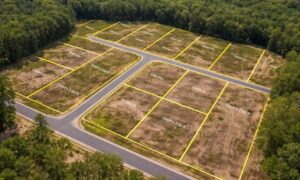
Most people order a property line survey for practical reasons. Maybe you plan to sell your home. Maybe you want to build a fence, add a driveway, or start a small renovation. In many cases, you expect the survey to confirm what you already believe about your property.
However, that is not always what happens.
Instead, a property line survey can uncover boundary issues that have gone unnoticed for years. When that happens, simple projects can quickly turn into tense neighbor disputes. These conflicts often feel sudden, confusing, and emotional—especially when both sides believe they are right.
Why Property Line Disputes Are Becoming More Common
Property disputes feel more common today, and there are clear reasons why.
First, modern surveying tools are far more precise than older methods. GPS equipment, updated records, and digital mapping allow surveyors to find boundaries with accuracy that was not possible decades ago. As a result, surveys now reveal issues that older measurements missed.
Second, many properties rely on assumed boundaries. Fences, tree lines, or shared driveways often stand where owners believe the property line exists. Over time, those assumptions feel like facts, even when they are not legally correct.
Finally, more homeowners are renovating, selling, or improving their property. Each of those actions often requires a property line survey. When the survey shows a different boundary, disputes surface quickly.
The Moment a Property Line Survey Changes Everything
A property line survey can shift a situation in an instant.
One day, both neighbors coexist peacefully. The next day, a survey shows that a fence, shed, or driveway crosses the legal boundary. Although nothing physically moved, the understanding of ownership suddenly changes.
This moment feels especially stressful because it often happens during an important life event. Home sales, construction projects, and refinancing already bring pressure. A boundary issue adds conflict at the worst possible time.
Common Neighbor Disputes Triggered by Surveys
Many disputes follow similar patterns.
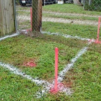
Fences cause some of the most common problems. A fence may sit several feet onto one property, even if it has been there for years. When a survey reveals that fact, emotions rise quickly.
Sheds, garages, and patios also create conflict. These structures cost money to build, so owners feel defensive when a survey shows encroachment.
Trees can also spark disputes. If a survey shows that a tree sits on one property but overhangs another, questions about trimming or removal often follow.
In all these cases, both sides usually feel shocked. After all, “we’ve always used that space” does not feel wrong—until the survey says otherwise.
Why Old Maps and Online Tools Create Confusion
Many homeowners rely on online property maps or county GIS tools. While those resources help with general planning, they do not replace a legal survey.
Online maps often show approximate boundaries. They lack the detail needed to define ownership accurately. However, people trust what they see on a screen, which creates confidence without legal backing.
Old deeds and hand-drawn maps can also cause confusion. Over time, descriptions change, landmarks disappear, and measurements lose clarity. When a modern property line survey compares all records and physical evidence, conflicts often appear.
The Legal and Financial Impact Homeowners Don’t Expect
When a neighbor disputes a survey result, the situation can escalate fast.
In some cases, owners must remove or relocate structures. In other cases, attorneys become involved. Even when disputes settle quickly, legal advice and delays add cost.
Property sales may also stall. Buyers and lenders often require clear boundaries. Until the issue is resolved, closings can fall apart or get delayed.
Ironically, these disputes often cost far more than the property line survey itself. That is why surveys act as protection, not problems.
Real-Life Situations That Start Boundary Conflicts
Most disputes begin with simple actions.
A homeowner replaces an old fence and wants it “on the line.” A neighbor disagrees once survey stakes appear.
A seller orders a survey for closing, only to discover a shared driveway crosses the boundary.
A homeowner applies for a permit, and the city requires a survey before approval.
In each case, the dispute does not come from bad intent. It comes from new information that changes expectations.
What a Property Line Survey Does—and What It Doesn’t
A property line survey defines legal boundaries using records, measurements, and physical evidence. Surveyors research deeds, locate monuments, and measure distances carefully.
However, surveyors do not decide who wins a dispute. They provide facts, not judgments. Courts or legal agreements handle ownership conflicts when needed.
Even so, a professional survey forms the foundation of any resolution. Without it, disputes rely on opinions instead of evidence.
How to Reduce Conflict Before Ordering a Survey
You cannot prevent every dispute, but you can reduce tension.
Talking with neighbors before ordering a property line survey helps set expectations. When people feel included, they react less defensively.
Understanding possible outcomes also matters. If you know a fence might not sit on the line, you can prepare emotionally and financially.
Most importantly, working with a licensed professional adds credibility. Clear communication and proper documentation reduce misunderstandings from the start.
Why a Licensed Surveyor Matters in Disputes
When disagreements arise, the quality of the survey matters.
Licensed surveyors follow state standards and professional methods. Their work holds up under scrutiny from neighbors, attorneys, and title companies.
In contrast, informal measurements or outdated drawings often fail to resolve conflict. Instead, they create more arguments.
A defensible property line survey provides clarity. Even if the result surprises everyone, it offers a reliable path forward.
How a Property Line Survey Protects You Long-Term
Although disputes feel stressful, surveys ultimately protect property owners.
They prevent future conflicts. They clarify ownership before money gets spent. They strengthen your position if disagreements escalate.
Most of all, they replace assumptions with facts. That clarity matters, especially when emotions run high.
Final Thoughts for Homeowners
A property line survey can feel like the start of a problem. In reality, it reveals issues that already existed.
Finding those issues early allows you to address them before they grow more costly. While disputes feel uncomfortable, clear boundaries create long-term peace.
Knowing where your property truly begins and ends is not just a technical detail—it is peace of mind.